Northern California forecast and heat wave: What to know, cooling centers, possible outages, health dangers
copyShortcut to copy
Link copied!
Updated: 5:46 PM PDT Jul 1, 2024
WE’LL BE FOLLOWING THIS THROUGHOUT OUR EVENING NEWSCAST. WE’RE ALSO FOLLOWING THIS. WE’VE GOT THE BEGINNING OF A HEAT WAVE. WE’RE NOW DAY THREE OF NORTHERN CALIFORNIA IN SOME SPOTS REACHING OVER TRIPLE DIGITS. THOSE TRIPLE DIGIT TEMPERATURES EXPECTED ACROSS OUR REGION FOR SEVERAL MORE DAYS, ACCORDING TO OUR METEOROLOGIST. NOW, MULTIPLE AGENCIES, INCLUDING UTILITIES AND FIRE DEPARTMENTS, ARE GEARING UP FOR THE CHALLENGES ANTICIPATED WITH THIS HOT WEATHER THIS WEEK. YEAH, WE HAVE TEAM COVERAGE ON THIS HEAT WAVE AND ITS IMPACTS. WE’LL GET TO KCRA 3’S, MARICELA DE LA CRUZ IN JUST A MOMENT. BUT FIRST WE WANT TO START WITH METEOROLOGIST HEATHER WALDMAN HEATHER. THERE’S ALSO AN INCREASED RISK OF FIRE DANGER. YEAH, BECAUSE OF THE HEAT WE HAVE THIS WEEK. BUT ESPECIALLY BECAUSE A DRY NORTH WIND IS GOING TO START TO PICK UP TONIGHT. AND FOR THE WEST SIDE OF THE VALLEY, IT’S GOING TO BE THERE TUESDAY. AND WEDNESDAY. BECAUSE OF THAT WE HAVE A RED FLAG WARNING THAT WILL GO INTO EFFECT AT 11:00. THIS EVENING AGAIN FOR THE VALLEY AND FOR SOME PARTS OF THE COASTAL HILLS IN THE BACKGROUND. OF COURSE, INTENSE HEAT TEMPERATURES TODAY WELL INTO THE TRIPLE DIGITS IN THE VALLEY. THEY WILL JUMP TO AROUND 108 DEGREES AS WE GO THROUGH TOMORROW AFTERNOON. AND THEY’RE NOT EXPECTED TO REALLY RELINQUISH EVEN AS WE GO THROUGH THIS WEEK. BUT I WANT TO FOCUS ON THE RED FLAG WARNING HERE FOR A BIT. AGAIN, THE FOCUS OF THE STRONGEST WINDS THAT NORTH GUSTY WIND THAT’S GOING TO BE ON THE WEST SIDE OF THE VALLEY. THAT’S A TYPICAL SPOT WHERE WE SEE THOSE WINDS REALLY BECOME A PROBLEM. IT’S BECAUSE OF THE DRY NORTH WIND AND VERY LOW HUMIDITIES THAT WERE CONCERNED THAT ANY FIRE THAT WERE TO START IN THIS AREA COULD GROW DANGEROUSLY FAST. I WANT TO BE CLEAR, AT THIS TIME OF THE YEAR, THE FIRE DANGER IS ALWAYS HIGH BECAUSE THE FUELS ARE DRY AND WE’RE PRONE TO SOME PRETTY HOT AFTERNOONS. BUT TUESDAY AND WEDNESDAY, ESPECIALLY WITH IT BEING INDEPENDENCE DAY WEEK, PEOPLE ARE CELEBRATING. YOU’VE GOT YOUR FIREWORKS. JUST BE EXTRA CAREFUL OVER THE NEXT COUPLE OF DAYS, ESPECIALLY IF YOU’RE IN A COMMUNITY LIKE WOODLAND OR VACAVILLE. THIS IS WHERE THE FIRE THREAT IS GOING TO BE PARTICULARLY HIGH. YOU GO FARTHER SOUTH OR TO THE EAST. THE WIND NOT QUITE AS MUCH OF A FACTOR, BUT FOR STOCKTON MODESTO THE FUELS IN THESE AREAS ARE DRY AND FOR THE LOWER FOOTHILLS IN AUBURN AND SONORA, WE’RE SEEING THE FUELS DRYING OUT THERE AS WELL. HERE’S WHERE THE TEMPERATURES STAND. NOW. WE’RE UP TO 102 DEGREES AT EXECUTIVE AIRPORT, SO THAT NUMBER STILL INCREASING HERE THIS AFTERNOON. WE’LL LOOK AHEAD
Northern California forecast and heat wave: What to know, cooling centers, possible outages, health dangers
copyShortcut to copy
Link copied!
Updated: 5:46 PM PDT Jul 1, 2024
Monday marks the start of a heat wave in Northern California, one that will increase the chances of wildfires happening amid sweltering heat and warm winds.KCRA 3 is calling Monday an Impact Day because of temperatures above 100 degrees. Another thing to look out for is a north wind, which is expected to increase the risk of wildfires. The heat could also pose health risks for those who are exposed for too long without proper cooling.Find a list of cooling centers here.Here is where to find public pools to cool off.Want to visit a water park? Here’s a list of locations.Here’s how to know the differences between sunburns, heat cramps, heat exhaustion and heatstroke. How to keep your pets safe amid hot summer temperatures Meteorologist Tamara Berg said temperatures will only continue to rise for the rest of the week. From Tuesday to Sunday, KCRA 3 is labeling those days as Alert Days because of the temperatures well above average and the high wildfire risk.The National Weather is also issuing a red flag warning from Monday at 11 p.m. through Wednesday. Wind gusts as strong as 30 mph are expected.In response, Pacific Gas & Electric Co. has notified thousands of its customers that it will shut off power in areas where its live electric lines could cause wildfires. The utility calls these planned outages Public Power Safety shutoffs.Sacramento Regional Transit said days of extreme heat can have a significant strain on light rail infrastructure and trains will operate at reduced speed. Meteorologist Heather Waldman said that overnight lows won’t provide much relief throughout the region. (See more in the video below.)Berg said it is likely the heat wave will last through the next seven days. See our Fire Threat Index below. | MORE | A 2024 guide for how to prepare for wildfires in CaliforniaHere are key websites that are important for all Californians during wildfire season.Cal Fire wildfire incidents: Cal Fire tracks its wildfire incidents here. You can sign up to receive text messages for Cal Fire updates on wildfires happening near your ZIP code here.Wildfires on federal land: Federal wildfire incidents are tracked here.Preparing for power outages: Ready.gov explains how to prepare for a power outage and what to do when returning from one here. Here is how to track and report PG&E power outages.Keeping informed when you’ve lost power and cellphone service: How to find a National Weather Service radio station near you.Be prepared for road closures: Download Caltrans’ QuickMap app or check the latest QuickMap road conditions here.REAL-TIME TRAFFIC MAPClick here to see our interactive traffic map.TRACK INTERACTIVE, DOPPLER RADARClick here to see our interactive radar.DOWNLOAD OUR APP FOR THE LATESTHere is where you can download our app.Follow our KCRA weather team on social mediaMeteorologist Tamara Berg on Facebook and X.Meteorologist Dirk Verdoorn on FacebookMeteorologist/Climate Reporter Heather Waldman on Facebook and X.Meteorologist Kelly Curran on X.Watch our forecasts on TV or onlineHere’s where to find our latest video forecast. You can also watch a livestream of our latest newscast here. The banner on our website turns red when we’re live.We’re also streaming on the Very Local app for Roku, Apple TV or Amazon Fire TV.
Monday marks the start of a heat wave in Northern California, one that will increase the chances of wildfires happening amid sweltering heat and warm winds.
KCRA 3 is calling Monday an Impact Day because of temperatures above 100 degrees. Another thing to look out for is a north wind, which is expected to increase the risk of wildfires. The heat could also pose health risks for those who are exposed for too long without proper cooling.
Meteorologist Tamara Berg said temperatures will only continue to rise for the rest of the week.
From Tuesday to Sunday, KCRA 3 is labeling those days as Alert Days because of the temperatures well above average and the high wildfire risk.
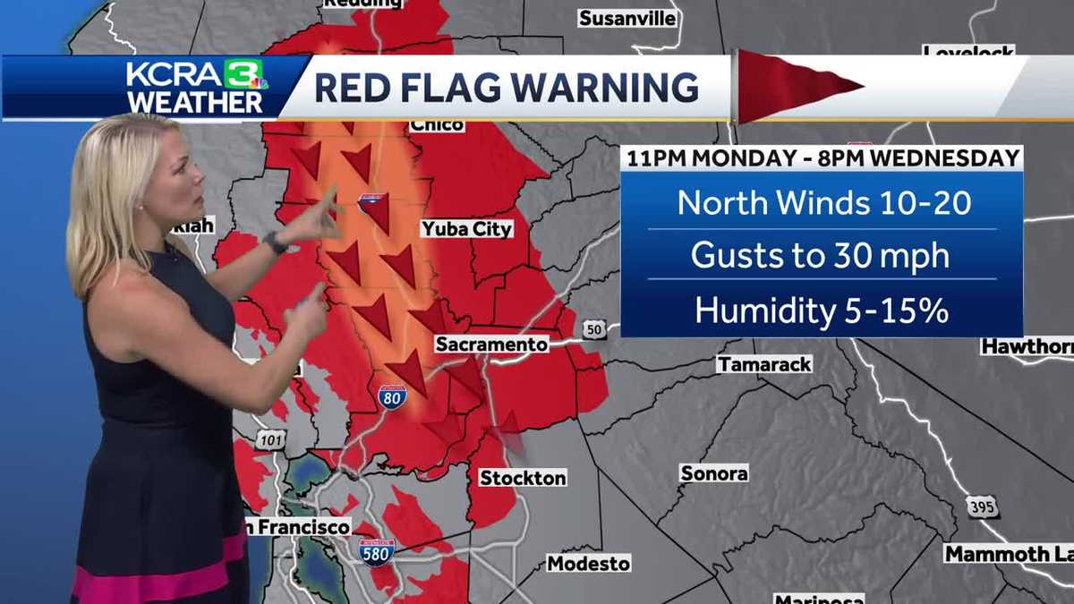
The National Weather is also issuing a red flag warning from Monday at 11 p.m. through Wednesday. Wind gusts as strong as 30 mph are expected.
In response, Pacific Gas & Electric Co. has notified thousands of its customers that it will shut off power in areas where its live electric lines could cause wildfires. The utility calls these planned outages Public Power Safety shutoffs.
Sacramento Regional Transit said days of extreme heat can have a significant strain on light rail infrastructure and trains will operate at reduced speed.
This content is imported from Twitter.
You may be able to find the same content in another format, or you may be able to find more information, at their web site.
Meteorologist Heather Waldman said that overnight lows won’t provide much relief throughout the region. (See more in the video below.)
Berg said it is likely the heat wave will last through the next seven days. See our Fire Threat Index below.
Slideshow
4 photos
1 of 4
2 of 4
3 of 4
4 of 4
Slideshow
4 photos
1 of 4
2 of 4
3 of 4
4 of 4
Slideshow
4 photos
1 of 4
2 of 4
3 of 4
4 of 4
Slideshow
4 photos
1 of 4
2 of 4
3 of 4
4 of 4
| MORE | A 2024 guide for how to prepare for wildfires in California
Here are key websites that are important for all Californians during wildfire season.
Cal Fire wildfire incidents: Cal Fire tracks its wildfire incidents here. You can sign up to receive text messages for Cal Fire updates on wildfires happening near your ZIP code here.Wildfires on federal land: Federal wildfire incidents are tracked here.Preparing for power outages: Ready.gov explains how to prepare for a power outage and what to do when returning from one here. Here is how to track and report PG&E power outages.Keeping informed when you’ve lost power and cellphone service: How to find a National Weather Service radio station near you.Be prepared for road closures: Download Caltrans’ QuickMap app or check the latest QuickMap road conditions here.
Click here to see our interactive traffic map.
TRACK INTERACTIVE, DOPPLER RADAR
Click here to see our interactive radar.
Here is where you can download our app.
Follow our KCRA weather team on social media
Meteorologist Tamara Berg on Facebook and X.Meteorologist Dirk Verdoorn on FacebookMeteorologist/Climate Reporter Heather Waldman on Facebook and X.Meteorologist Kelly Curran on X.
Watch our forecasts on TV or online
Here’s where to find our latest video forecast. You can also watch a livestream of our latest newscast here. The banner on our website turns red when we’re live.
We’re also streaming on the Very Local app for Roku, Apple TV or Amazon Fire TV.