
After blasting the western United States for the past 10 days, record heat is poised to shift into the eastern United States over the weekend and early next week.
Some parts of the east could see their hottest weather of the summer so far. “Widespread record values” are predicted as it becomes “dangerously hot for many,” the National Weather Service wrote in a discussion Friday.
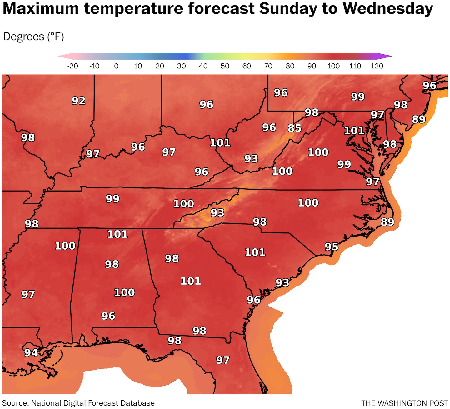
Records highs in the east are possible as soon as Friday and Saturday in parts of Georgia and the Carolinas. From Sunday through Wednesday, record heat will expand to cover much of the East Coast.
The Weather Service’s HeatRisk product shows numerous eastern cities reaching “extreme” Level 4 heat — the highest level on its 0-4 scale — for at least a day or two through early next week. The extreme heat will be most persistent and widespread from southern Louisiana to the Carolinas.
Even as the intensity of the heat in the West lessens, it will remain warmer than normal. “Much of the nation will experience above-average temperatures next week,” the Weather Service wrote.
Where the worst heat is now
Much of the western United States faces one more day of widespread extreme heat that could break numerous records even while its intensity has begun to diminish some in the Pacific Northwest.
Excessive-heat warnings cover much of California, Nevada and portions of surrounding states.
Much of the Desert Southwest and California Central Valley reached 110 degrees or higher Thursday and will do so again Friday. Palm Springs, Calif., hit 119 on Thursday, while Las Vegas reached 118, its record sixth straight day making it to at least 115 degrees. Its average high of 116.9 degrees over the past week was the highest on record by a wide margin, easily surpassing the previous mark of 115.1 in 2005.
Elsewhere, Salt Lake City should also rise near 105 Friday, while Sacramento soars to 110.
Heat advisories also extend eastward, covering parts of eastern Colorado, including Denver, parts of Wyoming, eastern Montana and western Nebraska. The heat will also extend to the Houston area, where hundreds of thousands remain without power after Hurricane Beryl.
In Denver, highs are expected to rise near and above 100 Friday through Sunday. Chris Bianchi, a broadcast meteorologist for 9News in Denver, described the heat wave as “very unusual and serious” in a post on X.
Where the heat is headed next
Record warmth takes a road trip from the west to the east over the weekend, where it will linger for a few days before returning westward.
Monday and Tuesday appear to be the hottest days of the upcoming stretch. Records are likely from the South into New England.
Atlanta, Charlotte, Raleigh, N.C., and Knoxville, Tenn., are forecast to flirt with record highs near 100 Sunday and Monday.
Highs in the mid-90s to around 100 will also reach the Mid-Atlantic on Monday, including D.C. Its forecast high of 101 would be the hottest of the year so far.
Highs well into the 90s should also spread over much of southern New England.
High levels of humidity will make it feel even hotter. A huge swath from the central Plains to the Mid-Atlantic and southward can anticipate heat indexes, which takes humidity into account, of 100 to 105. The steamiest locations could flirt with 110.
By Wednesday, the most extreme heat should sink southward, allowing more pleasant air to spread over the Midwest and Northeast.
The long-range forecast
After this next bout of high-end heat in the eastern United States, computer models project temperatures near or even below normal in about a week but hotter-than-normal weather is predicted for the Mountain West.
By late July, the most reliable long-range weather models suggest that large parts of the Lower 48 states may have to contend with above-average temperatures again, except perhaps for parts of the South.
Jason Samenow contributed to this report.