Northern California heat wave forecast: Triple digits continue Monday
The region faces more dangerous heat Sunday. Temps will flare up again mid-week before coming back down.
copyShortcut to copy
Link copied!
Updated: 7:49 AM PDT Jul 8, 2024
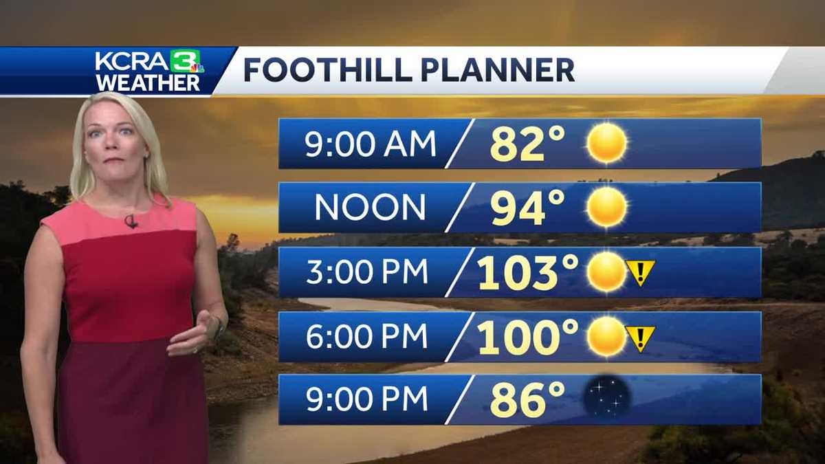
IT IS 619 RIGHT NOW, AND WE WANT TO GO AHEAD AND GET ANOTHER CHECK ON THE FORECAST. TALKING ABOUT A LITTLE BIT OF A BREAK IN THE HEAT. YEAH, YOU KNOW, TEMPORARY ONE. THAT’S IT. YOU KNOW IT’S JULY AND WE’VE BEEN SEEING THE HEAT JUST REALLY COME ON PRETTY STRONG FOR THE START OF THE MONTH. AND NOW WE’RE GETTING INTO OF COURSE THE EIGHTH OF THE MONTH TODAY. AND YEAH THE HEAT IS GOING TO LINGER. BUT AT LEAST IT’S GOING TO EASE TEMPORARILY HERE IN THE NEXT 24 TO 48 HOURS LIVE. LOOK OUTSIDE AS YOU TAKE IT TO RANCHO CORDOVA SKIES ARE MAINLY CLEAR AND IT’S A COMFORTABLE MORNING IF YOU’RE HEADING OUT IN THE AMERICAN RIVER TRAIL 62 DEGREES AS YOU STEP OUT THE DOOR THAT FEELS PRETTY GOOD. 65 HEADING OUT IN STOCKTON. WE’RE AT 69 DEGREES MODESTO AND 48. AS WE KICK OFF YOUR MONDAY IN LAKE TAHOE, AND ESPECIALLY AROUND THE WEST SHORE OF THE SIERRA, THERE ARE GOING TO BE SOME SMOKY SKIES AROUND THAT AREA DUE TO THE ROYAL FIRE THAT’S PUTTING OUT SOME SMOKE, AND THERE’S JUST NOT A LOT OF WIND TO MOVE THAT SMOKE AROUND THERE. AROUND THE TRUCKEE AREA. SO IF YOU ARE WAKING UP IN TRUCKEE OR AROUND THE OLYMPIC VALLEY, THIS MORNING, MAYBE YOU’VE EXTENDED YOUR FAMILY VACATION FROM THE FOURTH HOLIDAY. KEEP IN MIND, IF YOU DO SMELL SMOKE, IT’S A GOOD IDEA TO KEEP THE WINDOWS SHUT. AND ALSO DON’T BE OUTSIDE BREATHING IT IN FOR A LONG PERIOD OF TIME. I HAVE EAST WINDS AT TEN IN PLACERVILLE, BUT THE DELTA BREEZE IS REALLY HELPING THINGS OUT HERE IN FAIRFIELD AS THAT BREEZE IS USHERING IN SOME COOLER AIR. HENCE LEADING TO A DROP IN TEMPERATURES. BUT AS THAT BREEZE KIND OF DIES DOWN A BIT IN THE MIDDLE OF THE DAY, IT IS GOING TO ALLOW THINGS TO HEAT UP. SO EXPECTING A HIGH TODAY, ON THIS EIGHTH DAY OF JULY OF 102, THAT’S GOING ABOVE THE AVERAGE OF 94. WE’RE NOT GOING TO BREAK A RECORD TODAY. 110 IS THE RECORD THAT WAS GOING BACK ALL THE WAY TO 1905. BUT YOU NEED TO REALLY KIND OF PLAN AROUND THE HEAT. ONCE AGAIN, USE THE MORNING TO YOUR ADVANTAGE BECAUSE BY LUNCHTIME IT STARTS TO GET UNCOMFORTABLE. IF YOU’RE IN THAT DIRECT SUNLIGHT. AS WE HIT 90 DEGREES, THOSE HOURS BETWEEN ABOUT 3 P.M. AND 6 P.M. REALLY THE HOTTEST PART OF THE DAY AS WE REACH THAT HIGH OF 102. IN MANY VALLEY COMMUNITIES, IT’S GOING TO BE HOTTER THAN THAT IN THE FOOTHILLS, EVEN AS YOU’RE GETTING A RUNNING START THERE IN THE LOW 80S. BY 9 A.M., MID-NINETIES NOON 103 EXPECTED AROUND 3 P.M. AND IT’S GOING TO BE ALSO A VERY WARM DAY BY SIERRA STANDARDS. SUNSHINE AND 91 DEGREES IN SOUTH LAKE TAHOE. AS WE GO THROUGH THE PATTERN HERE, THAT AREA OF HIGH PRESSURE, IT’S GOING TO BUCKLE PREMATURELY AS WE GET INTO TOMORROW, ALLOWING THAT DELTA BREEZE TO COME THROUGH. BUT THEN ONCE WE GET INTO WEDNESDAY AND THURSDAY, IT JUST BUILDS BACK GRADUALLY. SO WEDNESDAY, THURSDAY, FRIDAY LOOKING PRETTY HOT AGAIN. IN FACT, I’VE GOT MORE ALERT DAYS TO AWARE YOU OF. AND THEN ONCE WE GET INTO FRIDAY AND SATURDAY, THOSE TEMPERATURES START TO
Northern California heat wave forecast: Triple digits continue Monday
The region faces more dangerous heat Sunday. Temps will flare up again mid-week before coming back down.
copyShortcut to copy
Link copied!
Updated: 7:49 AM PDT Jul 8, 2024
Monday marks day nine of triple-digit heat in Northern California.Meteorologist Tamara Berg said temperatures are forecast to dip below 100 degrees on Tuesday, which will offer some slight relief ahead of another increase in heat later this week.KCRA 3 is calling Monday an Impact Day because of how temperatures could affect outdoor activities. Impact Days are less severe than Alert Days, which we issue when weather conditions could pose safety or health risks if exposed for too long. As of Monday, we are expected to issue Alert Days for Wednesday and Thursday because of the heat and high wildfire risk. | Dig Deeper | Heather Waldman explains why climate change is making this level of heat more likely Read more from Tamara Berg about why this heat wave is happening Read more as Heather Waldman looks back at Northern California’s longest heat wave. Read more about why north winds are dangerous during wildfire seasons here See our Fire Threat Index below. | MORE | A 2024 guide for how to prepare for wildfires in CaliforniaHere are more resources for the heat waveFind a list of cooling centers here.Here is where to find public pools to cool off.Want to visit a water park? Here’s a list of locations.Here’s how to know the differences between sunburns, heat cramps, heat exhaustion and heat stroke.How to keep your pets safe amid hot summer temperaturesHow to prevent hot car deaths The best way to cool down your car without wasting gasHeading to the beach? The gear you use could make a difference Here are key websites that are important for all Californians during wildfire season. Cal Fire wildfire incidents: Cal Fire tracks its wildfire incidents here. You can sign up to receive text messages for Cal Fire updates on wildfires happening near your ZIP code here. Wildfires on federal land: Federal wildfire incidents are tracked here.Preparing for power outages: Ready.gov explains how to prepare for a power outage and what to do when returning from one here. Here is how to track and report PG&E power outages.Keeping informed when you’ve lost power and cellphone service: How to find a National Weather Service radio station near you.Be prepared for road closures: Download Caltrans’ QuickMap app or check the latest QuickMap road conditions here.REAL-TIME TRAFFIC MAPClick here to see our interactive traffic map.TRACK INTERACTIVE, DOPPLER RADARClick here to see our interactive radar.DOWNLOAD OUR APP FOR THE LATESTHere is where you can download our app.Follow our KCRA weather team on social mediaMeteorologist Tamara Berg on Facebook and X.Meteorologist Dirk Verdoorn on FacebookMeteorologist/Climate Reporter Heather Waldman on Facebook and X.Meteorologist Kelly Curran on X.Watch our forecasts on TV or onlineHere’s where to find our latest video forecast. You can also watch a livestream of our latest newscast here. The banner on our website turns red when we’re live.We’re also streaming on the Very Local app for Roku, Apple TV or Amazon Fire TV.
Monday marks day nine of triple-digit heat in Northern California.
Meteorologist Tamara Berg said temperatures are forecast to dip below 100 degrees on Tuesday, which will offer some slight relief ahead of another increase in heat later this week.
KCRA 3 is calling Monday an Impact Day because of how temperatures could affect outdoor activities. Impact Days are less severe than Alert Days, which we issue when weather conditions could pose safety or health risks if exposed for too long.
As of Monday, we are expected to issue Alert Days for Wednesday and Thursday because of the heat and high wildfire risk.
| Dig Deeper | Heather Waldman explains why climate change is making this level of heat more likely
See our Fire Threat Index below.
Slideshow
4 photos
1 of 4
2 of 4
3 of 4
4 of 4
Slideshow
4 photos
1 of 4
2 of 4
3 of 4
4 of 4
Slideshow
4 photos
1 of 4
2 of 4
3 of 4
4 of 4
Slideshow
4 photos
1 of 4
2 of 4
3 of 4
4 of 4
| MORE | A 2024 guide for how to prepare for wildfires in California
Here are more resources for the heat wave
Here are key websites that are important for all Californians during wildfire season.
Cal Fire wildfire incidents: Cal Fire tracks its wildfire incidents here. You can sign up to receive text messages for Cal Fire updates on wildfires happening near your ZIP code here. Wildfires on federal land: Federal wildfire incidents are tracked here.Preparing for power outages: Ready.gov explains how to prepare for a power outage and what to do when returning from one here. Here is how to track and report PG&E power outages.Keeping informed when you’ve lost power and cellphone service: How to find a National Weather Service radio station near you.Be prepared for road closures: Download Caltrans’ QuickMap app or check the latest QuickMap road conditions here.
Click here to see our interactive traffic map.
TRACK INTERACTIVE, DOPPLER RADAR
Click here to see our interactive radar.
Here is where you can download our app.
Follow our KCRA weather team on social media
Meteorologist Tamara Berg on Facebook and X.Meteorologist Dirk Verdoorn on FacebookMeteorologist/Climate Reporter Heather Waldman on Facebook and X.Meteorologist Kelly Curran on X.
Watch our forecasts on TV or online
Here’s where to find our latest video forecast. You can also watch a livestream of our latest newscast here. The banner on our website turns red when we’re live.
We’re also streaming on the Very Local app for Roku, Apple TV or Amazon Fire TV.