Northern California heat wave and forecast: What to know about fire danger, how to cool off
copyShortcut to copy
Link copied!
Updated: 6:27 AM PDT Jul 5, 2024
THERE AT THE FAIR, BUT AT LEAST THEY’VE GOT THE MISTERS. ALL THOSE OPPORTUNITIES TO STAY COOL. HERE’S A LIVE LOOK AT THE CONFLUENCE OF THE SACRAMENTO AND THE AMERICAN RIVERS. AND LET’S GET IT OVER TO METEOROLOGIST HEATHER WALDMAN FOR WHAT WE CAN EXPECT. AND THIS MIGHT BE A RECORD BREAKING DAY, RIGHT, HEATHER? WELL, UNOFFICIALLY, IT IS NOW FOR SACRAMENTO. I JUST CHECKED THE NUMBERS UPDATE EVERY 15 MINUTES DOWNTOWN, NOW AT 109 DEGREES. WE NEED THE NATIONAL WEATHER SERVICE TO CONFIRM THAT HIGH TEMPERATURE. THEY DO QUALITY CONTROL ON IT AND THEY RELEASE THE OFFICIAL HIGH AT ABOUT 545 EVERY DAY. BUT SO FAR, 109 IS THE HIGH FOR TODAY IN SACRAMENTO. THAT’S WHERE WE WERE YESTERDAY. THIS IS A LOOK AT OUR SIX DAY HEAT WAVE. SO FAR. TEMPERATURES EXPECTED TO PEAK ON SATURDAY JUST ABOVE 110 DEGREES FOR SACRAMENTO AND SOME OTHER VALLEY SPOTS. SO HERE WE ARE. WE’RE DIRECTLY UNDERNEATH THIS DOME OF HIGH PRESSURE AT THE BEGINNING OF THE WEEK, THIS HIGH WAS FARTHER TO THE WEST. WE WERE ON THE EASTERN SIDE OF IT. THAT’S WHERE WE GOT THAT NORTH WIND. THAT’S WHAT STARTED TO KICK UP THE TEMPERATURES. AND OF COURSE, IT ELEVATED THE FIRE RISK. EVEN FURTHER. WE DON’T HAVE THAT DRY NORTH BREEZE THROUGH THIS WEEKEND, BUT THE FIRE RISK DOES REMAIN ELEVATED. THE AIR IS VERY HOT. IT IS VERY DRY. THE FUELS ARE VERY DRY AS WELL. AND WE ALL SAW IT LAST NIGHT. WHAT THOSE FIREWORKS CAN DO. IF YOU ARE PLANNING ON CONTINUING YOUR CELEBRATIONS THIS WEEKEND, PLEASE BE CAREFUL. BUT HERE’S A LOOK AT TEMPERATURES ACROSS THE WEST. EVERYBODY UNDER THAT DOME OF HEAT. SO IT’S 97 RIGHT NOW IN YAKIMA, WASHINGTON, 94 DEGREES IN BEND, OREGON. THOSE TEMPERATURES A GOOD 15 TO 20 DEGREES ABOVE AVERAGE. THERE LOCALLY 105. THAT’S THE NUMBER AT EXECUTIVE AIRPORT. REMEMBER DOWNTOWN NOW IT OFFICIALLY 109 WITH POTENTIALLY ANOTHER HOUR OR SO OF WARMING TO GO. BUT HERE’S A LOOK AT THE BREEZE. WE HAD A NORTH FLOW THROUGH THE VALLEY EARLIER. WE’RE STARTING TO GET A LITTLE BIT MORE OF THAT ONSHORE FLOW COMING THROUGH SOLANO COUNTY. IT’S JUST BARELY REACHING SACRAMENTO COUNTY. IT’S NOT GOING TO HAVE THAT BIG, REFRESHING DELTA BREEZE EFFECT IN THE EVENING, BUT IT IS HELPING TO PUSH TEMPERATURES DOWN INTO THE 60S PRETTY CONSISTENTLY. WE’VE SEEN THAT SEVERAL TIMES THIS WEEK, AND TOMORROW MORNING VALLEY SPOTS SHOULD BE IN THE UPPER 60S TO LOW 70S. THAT’S NOT BAD CONSIDERING HOW HOT THE AFTERNOONS HAVE BEEN. SO BOTTOM LINE, IF YOU GOT SOMETHING TO DO OUTSIDE SATURDAY MORNING, IF YOU CAN DO IT CLOSE TO SUNRISE, IT’S GOING TO BE OKAY. BUT AS WE GET INTO THE AFTERNOON, YEAH, IT’S GOING TO GET HOT REALLY FAST. WE’RE SITTING UNDERNEATH THIS BIG AREA OF HIGH PRESSURE. MODELS HAVE BEEN CONSISTENTLY SHOWING THIS, MOVING TO THE EAST SUNDAY, MONDAY INTO TUESDAY. AND AS THAT HAPPENS, WE HAVE MORE ROOM FOR AN ONSHORE FLOW, MORE ROOM FOR SOME MORE COMFORTABLE AIR TO START TO MOVE IN. BUT SUNDAY IS STILL GOING TO BE A HOT DAY, WITH TEMPERATURES AROUND 105 DEGREES FOR THE VALLEY. HERE’S HOW TOMORROW LOOKS FOR THE SIERRA. YEAH, AN ESCAPE FOR THE VALLEY HEAT, BUT LOW 90S FOR TRUCKEE IN SOUTH LAKE TAHOE. THAT’S A HOT DAY UP IN THAT AREA FOR THE FOOTHILLS. WE’LL BE STARTING IN THE MID 70S AGAIN TOMORROW. PLACERVILLE 78IN THE MORNING, 103 IN THE AFTERNOON, 106 FOR A HIGH IN AUBURN AT THE COAST. YEAH, SOME COOLING AS YOU GO TO THE IMMEDIATE SHORELINE. SAN FRANCISCO WILL STAY IN THE UPPER 70S, BUT 107 FOR FAIRFIELD 106 IN LAKEPORT, NAPA SHOULD BE IN THE LOWER 80S TOMORROW. SAN JOAQUIN VALLEY SPOTS ANYWHERE FROM 107 TO 110 DEGREES. THERE IN STOCKTON. WE’LL SEE SIMILAR INTENSE HEAT FOR SACRAMENTO MORNING TEMPERATURES UPPER 60S TO LOW 70S. BUT THE AFTERNOON ANOTHER SCORCHER. 110 TO 111 DEGREES. AND, YOU KNOW, ONCE WE GET TO 110, THAT’S PRETTY RARE TERRITORY AS FAR AS HEAT GOES. TOMORROW’S RECORD FOR SACRAMENTO IS 105. FORECAST IS 111. WE SHOULD BREAK THAT. NO PROBLEM. WOW. AND THEN WE EASE UP A LITTLE BIT. THANK GOODNESS A LITTL
Northern California heat wave and forecast: What to know about fire danger, how to cool off
copyShortcut to copy
Link copied!
Updated: 6:27 AM PDT Jul 5, 2024
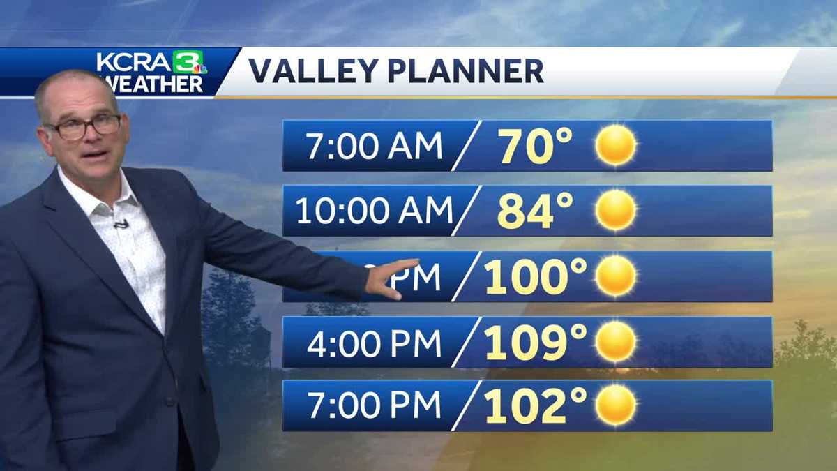
Triple-digit temperatures are not going anywhere soon for Northern California as a heat wave continues to challenge a region already vulnerable to wildfires.KCRA 3 is calling Friday an Alert Day because of both the dangerous heat that could lead to health issues and the high fire risks. Alert Days are issued when safety is a concern due to weather conditions. We have issued Alert Days since Tuesday and expect it to last through Sunday. Downtown Sacramento officially hit 110 degrees on Friday afternoon, Meteorologist Heather Waldman said, which set a new record high. The previous record was 108 degrees in 2007.Here is what to know about the day’s developments. As of Thursday morning, several fires continue to burn across the region.Evacuations remain near Oroville in Butte County for the Thompson Fire. Evacuation orders were reduced to warnings south of Placerville for the Moccasin Fire burning in El Dorado County. Illegal fireworks lit up the sky across Northern California. This led to several fires being sparked and forcing fire crews to have a busy Fourth of July evening.Some cooling centers across the region have extended their hours through Tuesday.What’s the forecast for Friday?Meteorologist Dirk Verdoorn said Friday could reach temperatures as high as 110 degrees, which is slightly hotter than Thursday was. The average temperature for this time of year is 94 degrees and the record is 108.Saturday is expected to be just as hot as Friday. Verdoorn said the record temperature for July 6 is 105, so that record is expected to be broken, too. A high-pressure dome of hot air will remain over California, which will keep temperatures hot in the afternoon but also not allow for much relief overnight. That will last through Sunday, but Verdoorn said by Monday, that dome could start moving away, allowing for a somewhat better Delta breeze to slightly cool off temperatures.Friday and Saturday will be slightly hotter, around 107-110 degrees. Next week will stay hot but it will be less intense. The region is looking at highs in the low 100s for Monday and Tuesday.KCRA 3 is expected to issue Impact Days on Monday and Tuesday next week. Impact Days, which are less severe than Alert Days, are issued when weather conditions may impact outdoor travel and activities. Verdoorn said Wednesday is likely going to mark of this heat wave, with its forecast high temperature of 98 degrees.Read more from Tamara Berg about why this heat wave is happening Read more as Heather Waldman looks back at Northern California’s longest heat wave. Read more about why north winds are dangerous during wildfire seasons here See our Fire Threat Index below. | MORE | A 2024 guide for how to prepare for wildfires in CaliforniaHere are more resources for the heat waveFind a list of cooling centers here.Here is where to find public pools to cool off.Want to visit a water park? Here’s a list of locations.Here’s how to know the differences between sunburns, heat cramps, heat exhaustion and heat stroke.How to keep your pets safe amid hot summer temperaturesHere are key websites that are important for all Californians during wildfire season. Cal Fire wildfire incidents: Cal Fire tracks its wildfire incidents here. You can sign up to receive text messages for Cal Fire updates on wildfires happening near your ZIP code here. Wildfires on federal land: Federal wildfire incidents are tracked here.Preparing for power outages: Ready.gov explains how to prepare for a power outage and what to do when returning from one here. Here is how to track and report PG&E power outages.Keeping informed when you’ve lost power and cellphone service: How to find a National Weather Service radio station near you.Be prepared for road closures: Download Caltrans’ QuickMap app or check the latest QuickMap road conditions here.REAL-TIME TRAFFIC MAPClick here to see our interactive traffic map.TRACK INTERACTIVE, DOPPLER RADARClick here to see our interactive radar.DOWNLOAD OUR APP FOR THE LATESTHere is where you can download our app.Follow our KCRA weather team on social mediaMeteorologist Tamara Berg on Facebook and X.Meteorologist Dirk Verdoorn on FacebookMeteorologist/Climate Reporter Heather Waldman on Facebook and X.Meteorologist Kelly Curran on X.Watch our forecasts on TV or onlineHere’s where to find our latest video forecast. You can also watch a livestream of our latest newscast here. The banner on our website turns red when we’re live.We’re also streaming on the Very Local app for Roku, Apple TV or Amazon Fire TV.
Triple-digit temperatures are not going anywhere soon for Northern California as a heat wave continues to challenge a region already vulnerable to wildfires.
KCRA 3 is calling Friday an Alert Day because of both the dangerous heat that could lead to health issues and the high fire risks. Alert Days are issued when safety is a concern due to weather conditions. We have issued Alert Days since Tuesday and expect it to last through Sunday.
Downtown Sacramento officially hit 110 degrees on Friday afternoon, Meteorologist Heather Waldman said, which set a new record high. The previous record was 108 degrees in 2007.
This content is imported from Twitter.
You may be able to find the same content in another format, or you may be able to find more information, at their web site.
Here is what to know about the day’s developments.
As of Thursday morning, several fires continue to burn across the region.
What’s the forecast for Friday?
Meteorologist Dirk Verdoorn said Friday could reach temperatures as high as 110 degrees, which is slightly hotter than Thursday was. The average temperature for this time of year is 94 degrees and the record is 108.
Saturday is expected to be just as hot as Friday. Verdoorn said the record temperature for July 6 is 105, so that record is expected to be broken, too.
A high-pressure dome of hot air will remain over California, which will keep temperatures hot in the afternoon but also not allow for much relief overnight. That will last through Sunday, but Verdoorn said by Monday, that dome could start moving away, allowing for a somewhat better Delta breeze to slightly cool off temperatures.
Friday and Saturday will be slightly hotter, around 107-110 degrees.
Next week will stay hot but it will be less intense. The region is looking at highs in the low 100s for Monday and Tuesday.
KCRA 3 is expected to issue Impact Days on Monday and Tuesday next week. Impact Days, which are less severe than Alert Days, are issued when weather conditions may impact outdoor travel and activities.
Verdoorn said Wednesday is likely going to mark of this heat wave, with its forecast high temperature of 98 degrees.
See our Fire Threat Index below.
Slideshow
4 photos
1 of 4
2 of 4
3 of 4
4 of 4
Slideshow
4 photos
1 of 4
2 of 4
3 of 4
4 of 4
Slideshow
4 photos
1 of 4
2 of 4
3 of 4
4 of 4
Slideshow
4 photos
1 of 4
2 of 4
3 of 4
4 of 4
| MORE | A 2024 guide for how to prepare for wildfires in California
Here are more resources for the heat wave
Here are key websites that are important for all Californians during wildfire season.
Cal Fire wildfire incidents: Cal Fire tracks its wildfire incidents here. You can sign up to receive text messages for Cal Fire updates on wildfires happening near your ZIP code here. Wildfires on federal land: Federal wildfire incidents are tracked here.Preparing for power outages: Ready.gov explains how to prepare for a power outage and what to do when returning from one here. Here is how to track and report PG&E power outages.Keeping informed when you’ve lost power and cellphone service: How to find a National Weather Service radio station near you.Be prepared for road closures: Download Caltrans’ QuickMap app or check the latest QuickMap road conditions here.
Click here to see our interactive traffic map.
TRACK INTERACTIVE, DOPPLER RADAR
Click here to see our interactive radar.
Here is where you can download our app.
Follow our KCRA weather team on social media
Meteorologist Tamara Berg on Facebook and X.Meteorologist Dirk Verdoorn on FacebookMeteorologist/Climate Reporter Heather Waldman on Facebook and X.Meteorologist Kelly Curran on X.
Watch our forecasts on TV or online
Here’s where to find our latest video forecast. You can also watch a livestream of our latest newscast here. The banner on our website turns red when we’re live.
We’re also streaming on the Very Local app for Roku, Apple TV or Amazon Fire TV.