
Play
Hurricane Beryl hammered the Cayman Islands this morning and is headed towards the Yucatan Peninsula next. Its final chapter in the Gulf of Mexico will likely include impacts in eastern Mexico and Texas.
Current status: The Cayman Islands continue to feel strong impacts from the back half of Hurricane Beryl as it charges towards the Yucatan Peninsula. Strong winds, heavy rain, and damaging waves are anticipated to affect parts of Mexico beginning Thursday night before Beryl makes landfall there early Friday morning.
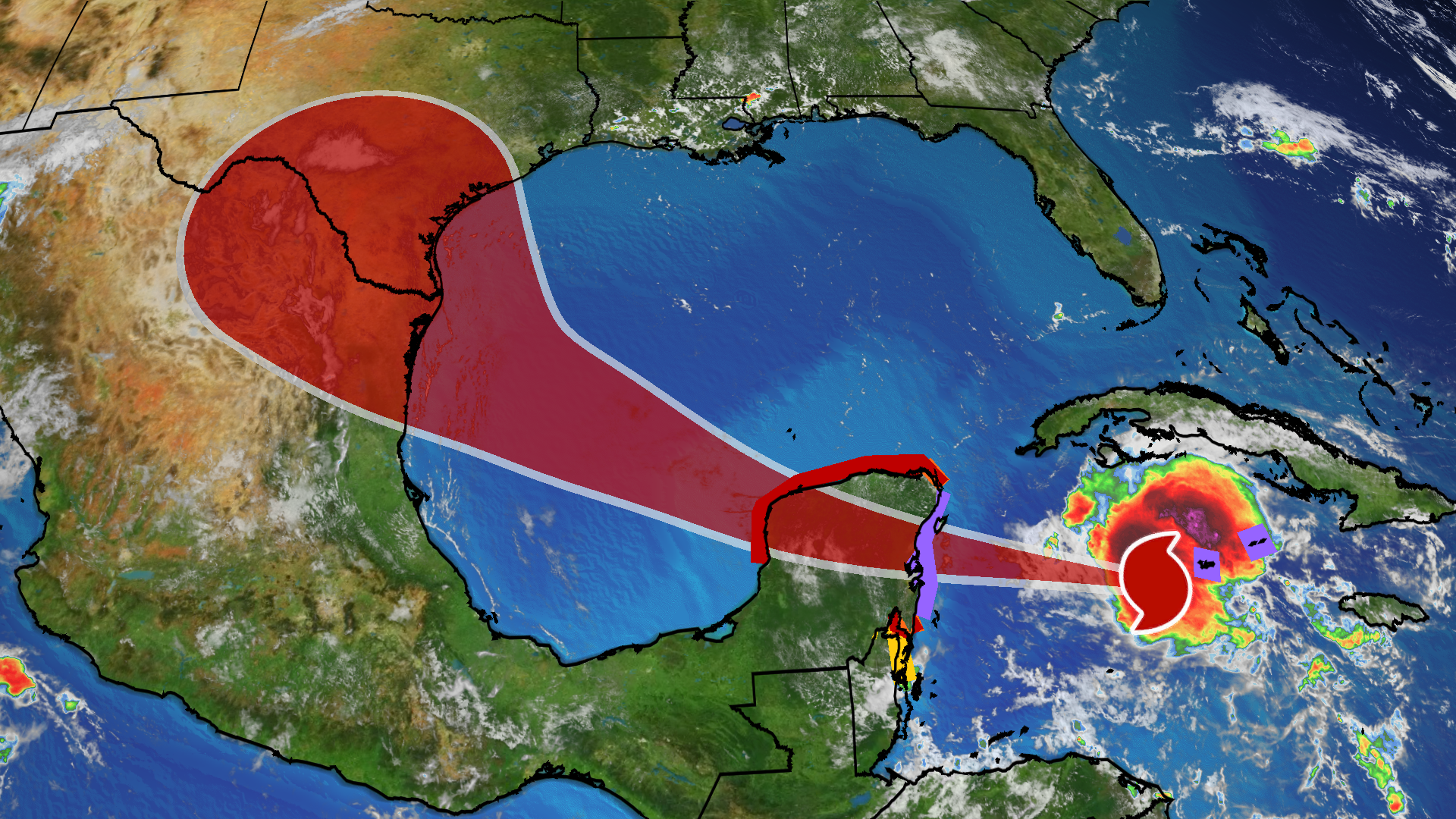
Beryl’s Current Wind Field Size(The orange circle shows the extent of the system’s tropical-storm-force winds (at least 39 mph). The purple circle indicates the extent of hurricane-force winds (at least 74 mph), according to the National Hurricane Center. Current sustained winds at reporting stations are also plotted. )
Here’s where warnings and watches are in effect: Hurricane warnings continue in the Cayman Islands and for parts of Mexico’s Yucatan Peninsula, including Costa Maya, Tulum, Cozumel and Cancún.
Hurricane watches and tropical storm warnings surround the hurricane warnings in Mexico’s Yucatan Peninsula north of Cancún and south of Costa Maya. A tropical storm watch is in effect for northern Belize as far south as Belize City.
Those in the Cayman Islands should remain in safe shelter until the hurricane passes. Areas under hurricane warnings on Mexico’s Yucatan Peninsula should rush preparations to completion.
(Issued by the National Hurricane Center and country governments )
Here’s what to expect next from Beryl across the Caribbean: Beryl will take a west-northwest track in the Caribbean Sea through the rest of this week. Although the hurricane will eventually lose some intensity because of increasingly hostile wind shear, it will still pose a considerable danger. Here’s the general timeline:
Thursday night and Friday: While conditions will deteriorate Thursday night, Beryl is expected to make a landfall as a hurricane in Mexico’s Yucatan Peninsula early Friday morning, anywhere from the Belize border and Costa Maya to Cozumel. Storm surge flooding, potentially damaging winds and flooding rain are all possible. Friday night: Heavy rain and strong wind gusts will continue in the Yucatan Peninsula through Friday. Beryl is expected to make a northwestward turn after emerging over the southwestern Gulf of Mexico Friday night.
(MORE: What The Forecast Cone Means, And Doesn’t)
Current Information And Projected Path(The red-shaded area denotes the potential path of the center of the tropical cyclone. It’s important to note that impacts (particularly heavy rain, high surf, coastal flooding, winds) with any tropical cyclone usually spread beyond its forecast path.)
U.S. concern: Beryl will emerge in the southwest Gulf of Mexico Friday night or early Saturday after being steered by a heat dome of high pressure over the Southeast U.S.
There is lingering uncertainty in Beryl’s future once it’s in the Gulf of Mexico.
That Southeast U.S. upper-level heat dome will both weaken and retreat off the Southeast coast, leaving a gap between that and a western U.S. heat dome.
Because of that, Beryl is expected to take a subtle northwest curl in the western Gulf of Mexico eastern Mexico or South Texas’ Gulf Coast sometime Sunday or early Monday. There is some chance Beryl could slow down its forward speed either near or after landfall.
Beryl will have lost strength by the time it reaches the southwest Gulf because of wind shear and land interaction. However it could still bring significant impacts to the Gulf Coast as either a tropical storm or hurricane. Some restrengthening is expected before its final landfall.
For now, residents along the Gulf Coast from eastern Mexico to Texas should monitor forecast updates closely and have their hurricane plans ready to go.
Coastal threats could begin this weekend: Well ahead of Beryl, onshore winds could lead to increasing surf, rip currents and coastal flooding along parts of the Gulf Coast from eastern Mexico to Texas and western Louisiana beginning as soon as Saturday, continuing until just after Beryl’s final landfall. The rip current threat could even extend farther east along the northern Gulf Coast, as well.
Keep this in mind if you have holiday weekend beach plans along these stretches of the coastline.
Just a couple of weeks ago, Tropical Storm Alberto triggered significant coastal flooding along the Texas coast.
Recap
It began on Friday, June 28 when the National Hurricane Center began advisories on Tropical Depression Two just over 1,200 miles east of Barbados. Six hours later it became Tropical Storm Beryl.
The following afternoon it was already Hurricane Beryl. By Sunday, June 30, the first on record in the Atlantic Basin in June. That’s a depression-to-Cat. 4 rapid intensification spurt in just 48 hours.
(MORE: The Early-Season Records Beryl Shattered)
After undergoing an eyewall replacement and passing between Barbados and Tobago, Beryl made landfall just after 11 a.m. EDT Monday, July 1 over the Grenadan island of Carriacou with maximum sustained winds of 150 mph. Among only two other Category 4 hurricanes in history near Grenada and St. Vincent and the Grenadines, Beryl was the strongest by wind speed.
Devastation was widespread on Carriacou Island, with vegetation largely stripped bare and numerous homes damaged or destroyed.
Downed trees, flooded streets, power outages and storm surge flooding was reported in the Grenadines, Grenada, Barbados and Tobago.
While its eyewall passed south of Barbados, a 69 mph gust was clocked early Monday at Grantley Adams International Airport, the island’s major airport. Grenada clocked a wind gust up to 121 mph as the center of Beryl tracked just north of the island. A gust to 64 mph was reported on St. Lucia, as well.
Just 12 hours after its southern Windward Island landfall, Beryl became the record earliest Category 5 Atlantic Basin hurricane on the evening of July 1. The following day, its winds topped out at 165 mph, the strongest July hurricane by wind speed on record in the Atlantic Basin.
Beryl brushed the southern coast of Jamaica on Wednesday, bringing heavy rainfall and damaging winds. Winds gusted as high as 81 mph at Norman Manley International Airport on a peninsula south of the country’s capital city, Kingston, Wednesday afternoon. This is the strongest hurricane to strike Jamaica in almost 17 years, since Hurricane Dean in 2007.
MORE ON WEATHER.COM
- Hurricane Beryl’s Most Eye-Popping Satellite Images
- How To Prepare For Hurricane Season
- What’s Been Deadliest In US Hurricanes, Tropical Storms Lately May Surprise You